8-5. SCALE DETERMINATION
Before a photograph can be used as a map supplement or substitute, it is necessary to know its scale. On a map, the scale is printed as a representative fraction that expresses the ratio of map distance to ground distance, For example:
On a photograph, the scale is also expressed as a ratio, but is the ratio of the photo distance (PD) to ground distance. For example:
The approximate scale or average scale (RF) of a vertical aerial photograph is determined by either of two methods; the comparison method or the focal length-flight altitude method.
a. Comparison Method. The scale of a vertical aerial photograph is determined by comparing the measured distance between two points on the photograph with the measured ground distance between the same two points.
| SCALE (RF |
= |
Photo Distance |
| ———————— |
| Ground Distance |
The ground distance is determined by actual measurement on the ground or by the use of the scale on a map of the same area. The points selected on the photograph must be identifiable on the ground or map of the same area and should be spaced in such a manner that a line connecting them will pass through or nearly through the center of the photograph (Figure 8-8).
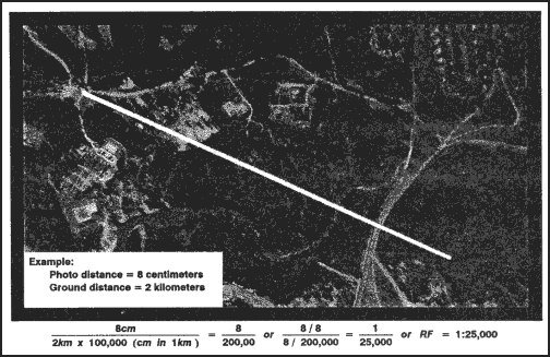
Figure 8-8. Selection of points for scale determination.
b. Focal Length-Flight Altitude Method. When the marginal information of a photograph includes the focal length and the flight altitude, the scale of the photo is determined using the following formula (Figure 8-9).
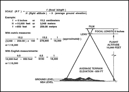
Figure 8-9. Computation of scale from terrain level.
When the ground elevation is at sea level, H becomes zero, and the formula is as shown in Figure 8-10.
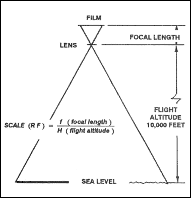
Figure 8-10. Basic computation of scale from sea level.
|